The St. Lawrence valley in southeastern Ontario was once lined with homesteads and farms that hugged the historic waterway. The landscape was dotted with small towns, villages, and hamlets, including places like Aultsville, Moulinette, and Wales. Migrants from eastern and central Canada were joined by people from around the world and together they formed thriving communities.
The settlements were hubs of activity for the growing agricultural industries in the valley. Gradually, industrial interest in the area grew, as entrepreneurs sought to harness the water resources and electric power potential along the vast waterway. Soon the farmers were joined by industrialists and the entire valley boomed in the late 19th century. The small communities were quickly put on the map and even one of Ontario’s premiers hailed from the area. Although the population grew, the stretch between the small cities of Cornwall and Brockville remained a collection of small communities, often home to multi-generational families who shared a love of the land.

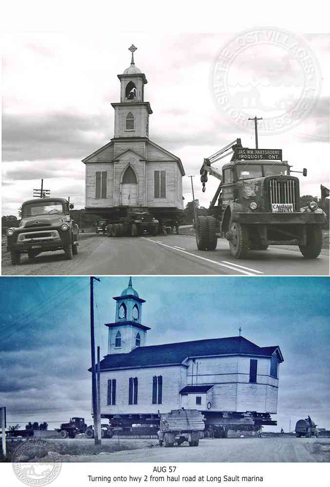
On July 1 1958, now known locally as “inundation day”, the flooding began. But there was a lot of preparation that preceded the momentous event. First, numerous communities had to be emptied and nearly 7,000 residents had to be relocated. Hundreds of buildings were moved in one of the largest community relocations of its time. Buildings were lifted off their foundations and placed onto trucks, and then slowly pulled to their new locations. But most buildings were scheduled to be demolished and families were minimally compensated for the property loss. Many residents at the time noted that the monetary compensation only covered their physical costs and the emotional and mental toll was never addressed. After the displacement, some families continued to live in the St. Lawrence area, determined to establish new communities, but others couldn’t face the traumatic memories and chose to leave the area altogether.
With the planned disappearance of so many communities, some people decided to take advantage of rare opportunities. For example, it was decided that a fire experiment would be conducted on the community of Aultsville. Shortly before the flooding, after some community buildings had been removed, the old town was deliberately set alight. Scientists were present to study how fires started within a structure and travelled from building to building, hoping to determine the best ways for combatting large and complex fires. But many community members were there too, watching their beloved buildings go up in flames. While many have since praised the Aultsville fire as a ground-breaking moment for research, others continue to recount the trauma of seeing their community burn to the ground.
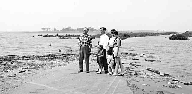
Early in the morning on July 1, the dam was operational and the waters of the St. Lawrence River slowly began to rise. Some residents turned out to witness the eerie scene as the waters of the St. Lawrence slowly covered the roads they had walked on for years and overcame the foundations of where they once called home. After four days of flooding, the water lapped at new shorelines and “Lake St. Lawrence” was officially created. The following year the seaway was completed, and Queen Elizabeth attended the inauguration. The opening of the seaway, with all of its innovation, was hailed as an engineering marvel that would transform transportation and shipping in central North America.
When the seaway was flooded, numerous ecological features were lost. The wetlands that had characterized the shorelines for countless generations were disrupted, some species of fish went nearly extinct and invasive species have gradually worked their way into the ecosystem. The grand rapids that had attracted so many people to the area for millennia were gone, the water now eerily calmed.
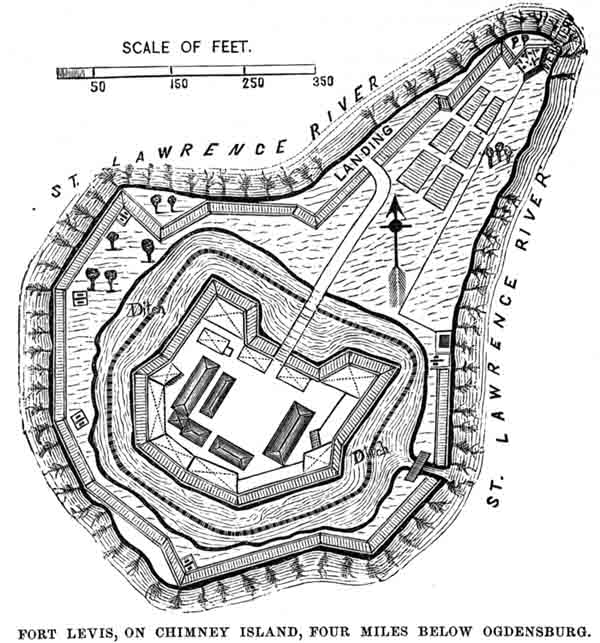
Before the flooding, there were numerous islands dotting the middle of the river; now they were shrunk or completely lost. One flooded island was historically known as Isle Royale (later Fort Levis), established by the French in the late 1700s. The fort was an important line of defense in the middle of the St Lawrence, now located near present-day Prescott. It was a final stronghold for the French before they surrendered to the British in 1760. The basic outline of the fort was still visible before the seaway was flooded and you can still see a tiny portion of the high ground poking up above the surface of the river. It’s likely that archaeological deposits are still below the water’s surface to this day.
In fact, the flooding of the St Lawrence River transformed the area into a widely renowned spot for scuba diving. People from all over the world come to explore the many shipwrecks which have occurred over the years. But others come specifically to look at the remnants of the lost villages. Sometimes you don’t need to dip your head below water to see the ghostly evidence. Some streets, foundations and community markers are visible when the water is clear and, when the levels are seasonably low, parts of the old villages are exposed to the fresh air once again.

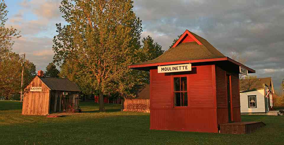
Some of the buildings from the lost villages were relocated to two open air museums: the Lost Villages Museum near Long Sault and Upper Canada Village near Morrisburg. The Lost Villages Museum tells the story of the communities and residents that existed prior to the flooding. The museum showcases some of the saved buildings, but also highlights the pain of the community’s loss. Upper Canada Village also showcases saved buildings, but encourages visitors to immerse themselves in the 19th century and remember life as it once was.
Although different in their mandate, both museums contain buildings from communities that are now under the waves of the St. Lawrence. The buildings are also filled with furniture and artifacts dating from different time periods and belonging to various families. With so many objects from disparate places, many people aren’t surprised to learn that the museums could be haunted. Whether spirits have attached themselves to their beloved homes or artefacts that were removed, or they remain tied to the land that was lost, visitors and staff at both museums have reported numerous spooky encounters. In fact, the Lost Villages Museum has so many documented cases of the paranormal, it is regularly opened for investigations and Upper Canada Village is a popular site for the Haunted Walk during the summer months.